 Texas
Tornado Statistics
Texas
Tornado Statistics Texas
Tornado Statistics
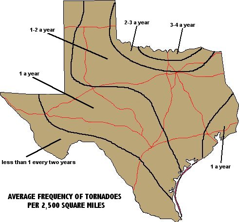
Texas lies on the southern end of Tornado Alley. Texas' location between the Gulf of Mexico on the southeast and the Rocky Mountains on its western periphery make it a prime area for the formation of tornadoes. An average of 153 tornadoes touch down in Texas each year. Tornadoes may occur in any month, but occur most often during April, May and June between the hours of 4:00 p.m. and 8:00 p.m. During the period 1959-2000, 6,417 tornadoes were reported in Texas, with 63% occurring from April-June and 33% occurring in May. From 1950-2007, Texas encountered 84 tornadoes with a strength of F4 or higher (winds > 207 mph). Texas ranks 11th among the 50 states in density of tornadoes with an average of 5.7 tornadoes per 10,000 square miles, per year. The U.S. record for the fastest tornado winds occurred at Wichita Falls in northwest Texas on April, 2, 1958 with a wind speed of 258 mph. The current record for number of U.S. tornadoes in one year is 2004 with 1,817 tornadoes. The average number per year for the last 10 years is 1,270. During 2008, 1,690 tornadoes were confirmed in the U.S, with 595 reported during May 2008.
|
Top 10 Texas counties with reported tornadoes from |
|||
| County | Location | Major City | # |
| 1. Harris | Gulf Coast | Houston | 212 |
| 2. Hale | Panhandle | Plainview | 116 |
| 3. Galveston | Gulf Coast | Galveston | 106 |
| 4. Jefferson | Gulf Coast | Beaumont | 100 |
| 5. Nueces | Gulf Coast | Corpus Christi | 93 |
| 6. Dallas | North Texas | Dallas | 82 |
| 7. Galveston | Gulf Coast | Galveston | 79 |
| 8. Carson | Panhandle | Amarillo | 79 |
| 9. Tarrant | North Texas | Ft. Worth | 78 |
| 10. Lubbock | Panhandle | Lubbock | 77 |
|
Top 10 strongest Texas tornadoes |
|||||||
|
Counties affected |
Area in Tx | Date | Fujita |
Distance |
Width |
Fatalities |
Injuries |
| 1. McLennan | Central | 5-11-53 | 5 | 20.9 | 1750 | 114 | 597 |
| 2. Lubbock | Panhandle | 5-11-70 | 5 | 10.6 | 4000 | 26 | 500 |
| 3. Williamson | Central | 5-27-97 | 5 | 5.1 | 1950 | 27 | 12 |
| 4. Wichita | Northwest | 4-30-64 |
5 |
4.7 | 1500 | 7 | 111 |
| 5. Brown | Central | 4-19-76 | 5 | 10.5 | 1320 | 0 | 11 |
| 6. McLennan, Bosque | Central | 5-06-73 | 5 | 10.6 | 300 | 0 | 0 |
| 7. Archer, Wichita, Clay | Northwest | 4-10-79 | 4 | 34.1 | 2640 | 42 | 1740 |
| 8. Swisher, Armstrong, Briscoe, Gray | Panhandle | 4-02-82 | 4 | 65 | 2640 | 16 | 42 |
| 9. Tom Green | Southwest | 5-11-53 | 4 | 9.9 | 2640 | 13 | 159 |
| 10. Lamar, Red River | North | 4-02-82 | 4 | 23 | 750 | 10 | 170 |
|
Top 10 Texas tornadoes with longest
distance on ground |
||||
|
Counties affected |
Area in Tx | Date |
Distance |
Width |
| 1. Travis, Williamson, Milam, Robertson, Leon, Houston | Central |
4/30/54 |
139.9 | 2640 |
| 2. Parmer, Randall, Armstrong, Carson, Gray | Panhandle |
4/17/70 |
130.0 | 2640 |
| 3. Val Verde, Maverick, Kinney, Zavala, Frio | Big Bend |
5/15/80 |
99.8 | 120 |
| 4. Hale, Floyd, Swisher, Briscoe, Hall, Donley | Panhandle |
4/17/70 |
96.6 | 2640 |
| 5. Armstrong, Carson, Carson, Gray, Roberts, Hemphill | Panhandle | 4/13/73 | 90.1 | 450 |
| 6. Parmer, Delta, Randall, Potter | Panhandle | 5/24/57 | 70.1 | 100 |
| 7. Trinity, Angelina, Nacogdoches, San Augustine | Southeast | 4/30/54 | 68.8 | 2650 |
| 8. Swisher, Briscoe, Armstrong, Donley, Gray | Panhandle | 4/18/70 | 65.0 | 2640 |
| 9. Gregg, Harrison | East | 5/03/58 | 59.2 | 1320 |
| 10. Williamson, Lee | Southeast |
9/04/56 |
56.6 | 1750 |
Tornado statistics and chart data source: National Climatic Data Center, Asheville, NC.
Texas Top 10 climate extremes, Texas precipitation records, Texas temperature records, Texas all-time weather records, current Texas weather, Texas city climate descriptions, Texas Tornado and Severe Thunderstorm Watch climatology, average freeze dates, interesting Texas weather facts, Texas climate information, Texas weather forecasts and Temperature / Precipitation records for each U.S. state
![]()